
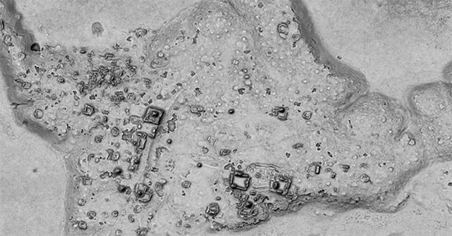
The forest seems unbroken from the air. Below its green roof, a broad rise may be a platform and a straight ridge may be an old road. Maya lidar discoveries begin by changing the view, stripping away leaves in a digital map so that traces of a city can emerge.
Lasers measure distance rather than read minds
Lidar sends laser pulses toward the ground and measures the light that returns. From those travel times, a survey builds a detailed set of points. The method maps shape and height; it does not directly reveal a building's age, name, purpose, or the beliefs of its builders.
A single airborne pass can gather many more measurements than a team walking through thick forest could easily record. The great gain is coverage. Small features begin to make sense when viewed beside larger slopes, water channels, plazas, and links between distant groups of structures.
Some light reaches gaps in the green roof
The forest canopy blocks many pulses. But some light passes through openings and reaches the ground; Researchers identify likely ground returns and use them to model the land surface. This does not mean lasers simply see through solid leaves like a magical camera in an adventure film.
The map is built from many samples, not one perfect beam. Dense plants, steep slopes, and survey settings affect the result. Areas with too few useful points may need extra care, especially when a faint bump could be either a ruin or a natural feature.
Related Stories
A landscape can reveal more than one temple
Ancient roads, raised fields, terraces, and building platforms can appear together in a lidar map. Their positions reveal how people moved and used land beyond a famous temple. This wider view can challenge the idea that a large settlement consisted only of scattered stone monuments in empty forest.
Imagine tracing a causeway from one mapped cluster to the next. It turns an isolated mound into part of a network. Water routes and farmed ground then become as key to the story as a tall pyramid that first catches the eye.
A striking shape still needs a ground check
Field surveys test what the remote map suggests. Teams visit features, document stonework, and seek dated material in its proper setting; a digital rectangle may be a useful lead. But it does not by itself prove a palace, fix a date, or identify a particular Maya ruler.
This is where patient work replaces the sudden reveal. Pottery, building phases, and earlier reports can help place a feature in time. The map guides those questions.
It does not make excavation or local knowledge less useful, and it cannot recover every lost detail.
Discovery brings duties as well as new maps
Mapping ruins can improve research and protection, but precise locations can also expose sites to looting. Good projects work with heritage bodies and local communities. Sharing a broad finding does not always need publishing every vulnerable feature or turning a sacred and fragile landscape into a treasure map.
The most lasting result may be a better plan for care. A road project or fire can harm ruins no tourist has seen. Knowing where a whole settlement extends helps people think beyond one restored temple and protect the less visible places around it.
Frequently Asked Questions
A map can reveal a shape without telling its age or use. These questions keep that limit clear. Laser data helps teams choose where to look, while a ground visit tests what the marks mean and adds details that a view from the air cannot show.
Does lidar see through stone walls?
No, the beam needs a path to a surface and a return from it. In a forest, some light reaches gaps among leaves, not a route through solid stone walls.
Can a lidar map date a ruin?
Not alone. A mapped shape may suggest a kind of ruin, but dates need other clues, such as known building phases, pots, or suitable material found in a secure setting.
Why do archaeologists still visit mapped sites?
A visit tests the map's clues and records what is there. Damage, stonework, and small finds add evidence that height points alone cannot supply, even when the digital view is very clear.